Site containing excellent military
maps of
South East
Asian War - Area Of Operations (The Vietnam War)
http://www.nexus.net/~911gfx/sea-ao.html
Drilling down to the I Corps area:
http://www.nexus.net/~911gfx/ne4816.html
Map showing
http://www.nexus.net/~911gfx/vietnam/maps/ne48-16/ne48_16h.html
For your convenience
in reading any of the maps at the above links, the following reference information
is provided:
|
Glossary
for common terms (note:
diacritic marks have been omitted) |
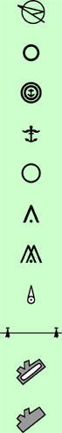
Map Symbols |
||
|
A., An, Ap Ban Co Cua Dak Dam Dong H., Hoi, Houay,
Houei Huong Karum Khe Ko Lang Ngon Nong truong Nui P., Phou, Pou Pha Phu R., Rach, Rao Se, Song, Suoi Thon Vinh Vinh Xa, Xom Xe Xuan |
village village village mountain estuary stream lagoon hill, mountain stream village stream stream mountain village stream agricultural center hill, mountain mountain lagoon village stream stream village gulf village village stream village |
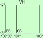
Field limits unknown, Field limits and runway, Seaplane base Seaplane (emergency) Heliport Obstruction Group obstruction Radio facility obstruction Power Aerodrome (field limits Aerodrome (field limits, with Aid to locating coordinates: Basic 15° |
|
Back to main Gary Linderer page
Don C. Hall and Annette R. Hall
Website and graphics created by Annette Hall
September 3, 2004